The Great Escape: The Haute 5 Weekend Getaways for Las Vegans

Las Vegas braces itself for another hot summer when Memorial Day hits next week. Instead of dealing with all the tourists coming to The Strip, take advantage of the three-day weekend and hit the road to escape the city. One of the advantages to living in Vegas is the easy access to some nature’s most stunning displays. Here are the Haute 5 weekend getaways with a nod to the national parks close at hand.
Grand Canyon via helicopter
By car, it’s 290 miles to one of Mother Nature’s greatest treasures, the Grand Canyon. But skip the drive and fly down via helicopter for a scenic tour and you’ll be down and back in four hours.
Maverick Helicopters offers a trip down to the Grand Canyon Skywalk, a glass-bottomed cantilever bridge that spans 70 feet over the West Rim of the canyon and sits 4,000 feet above the Colorado River. If you plan your trip right, you can return to Vegas at dusk for stunning views of the Hoover Dam and Lake Mead, the largest man-made lake in the world. Then you fly over the Strip before returning to solid ground. The tour starts at $489 per person and includes transportation from your hotel.
Maverick Helicopters, 6075 Las Vegas Blvd. S., 702.261.0007.
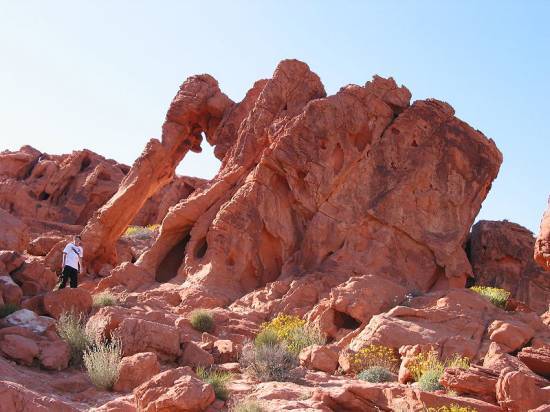
Valley of Fire State Park
Just 55 miles from Las Vegas sits a breathtaking state park with eroded red sandstone formations. Make Valley of Fire, where the Aztec sandstone formations draw the crowds, a day trip to escape the city.
Sands deposited some 135 million years ago and sculpted by the wind create formations that will blow your mind. Look for the Elephant Rock (pictured) and Seven Sisters along Highway 169, the main east-west road through the park. Drive along a two-mile scenic route for more stunning views and feel like your making your own car commercial. Stop at Atlatl Rock to look at petroglyphs.
The park has some hiking options, including a three-mile jaunt from Rainbow Vista that leads to Fire Canyon, the spot where Captain Kirk met his end in Star Trek: Generations.
Getting there: From Las Vegas, drive north on I-15 for 33 miles to Highway 169. Drive east 17 miles to reach the park’s western entrance.
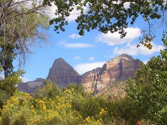
Zion National Park
Just 164 miles north of Las Vegas sits Zion National Park in Utah. And within this treasure is Zion Canyon (pictured), a 15 mile long and up to half a mile canyon made up of reddish- and tan-colored Navajo Sandstone along the north fork of the Virgin River.
You can drive through a six-mile scenic route that gives you access to many of the park’s main attractions. Or go east from Springfield at the main entrance to the park, and travel along Zion-Mount Carmel Highway through two narrow tunnels and past pink, orange and white rock formations like Checkerboard Mesa.
The Kolob Canyons in the park’s northwestern corner has its own entrance off I-15 at exit 40. A five-mile scenic route there takes you to the Finger Canyons. Try one of the hiking trails to reach the Kolob Arch, possibly the world’s largest natural arch reaching 310 feet.
Getting there: Take 1-15 north for 164 miles, traveling through winding curves in Arizona and onto the foothills of Utah. Take exit 16 in Utah onto Highway 9 to Springdale.
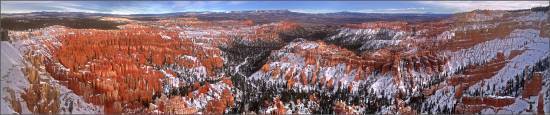
Bryce Canyon National Park
Just northwest of Zion National Park is Bryce Canyon with its misleading name. The canyon wasn’t formed by a river but by frost wedging. For 200 days a year, the temperature goes above and below freezing to shatter and pry rock apart. And the canyon is actually a giant natural amphitheater on the eastern side of the Paunsaugunt Plateau. Those geological structures are called hoodoos and come in stunning red, orange and white colors.
Getting there: Follow the directions to Zion National Park, then follow Highway 9 east through Zion National Park to Highway 89. Travel north to Highway 12, then drive east to Highway 63. From there, drive south to Bryce Canyon National Park.
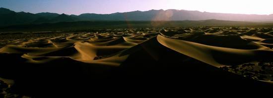
Death Valley National Park
Death Valley is the largest national park outside of Alaska, taking up 5,156 square miles of the desert in California bordering Nevada. But hit this spot sooner rather than later; temperatures easily hit 120 degrees and higher during the day. Yes, it’s the hottest, lowest and driest spot in North America.
You can find the lowest point at Badwater, a basin 282 feet below sea level, a mere 76 miles east of Mount Whitney, the highest point in the contiguous United States at 14,505 feet.
Stop by Furnace Creek for exhibits and an orientation film at the visitor’s center, and be sure to ask about road conditions and the weather forecast. Load up on water and gas, too. Then head north out to Salt Creek, the eerie Devil’s Cornfield and the Sand Dunes (pictured) that will make you want to leave your footprints in the windblown sand. South of Furnace Creek is Golden Canyon, but hike it late in the afternoon so you see how the canyon got its name.
Getting there: Take I-15 south to Blue Diamond Road, then head west through the Spring Mountains to Pahrump. Take Bell Vista Road to Death Valley Junction and then Highway 190 to the park.
Related Articles

Haute Takes: Personal Style Died the Moment the Algorithm Decided What You Should Wear
Haute Takes Coastal grandma, office siren, dark academia, quiet luxury, mob wife. Just a few buzzword names to describe the epidemic of consumerist fashion culture. If you bought into even half of these in the last two years, you have a closet full of clothes that contradict each other, a credit card statement that tells […]

Inside Hôtel Martinez’s Summer 2026 Program — the French Riviera at Its Very Best
Hôtel Martinez in Cannes launches its summer 2026 calendar — from La Guinguette du Martinez dinner series to beachside breakfasts.

How Hockey Became Gen Z’s Favorite Sport
Something happened this spring that nobody fully predicted. Millions of people who had never watched a hockey game in their lives sat down for the Stanley Cup Playoffs and did not get up. The 2026 playoffs averaged 1.8 million viewers across all broadcasts, the most-watched in U.S. history, surpassing a record that had stood since […]

The Odyssey Is 2,700 Years Old and It Has Never Felt More Culturally Relevant
I spent two years studying Classical Studies through the University of Cambridge’s curriculum, covering Roman and Greek architecture, Greek and Roman civilization, and classic literature. I read all of Homer’s classics, memorized the significance of the art and functionality on Greek pottery, and spent more time than I care to admit thinking about the way […]

Luxury Hotel Collaborations are Dominating This Summer
From Gucci at La Rose des Vents to Dolce & Gabbana in Portofino, these are the luxury hotel and fashion collaborations this summer.

The Ultimate Insider World Cup Guide to Miami, According to David & Isabela Grutman
David and Isabela Grutman share their insider Miami guide for the World Cup — from Gekkō and Komodo to LIV watch parties and more.
Latest Stories
Trending Articles


Related Articles
Haute Takes: Personal Style Died the Moment the Algorithm Decided What You Should Wear
Haute Takes Coastal grandma, office siren, dark academia, quiet luxury, mob wife. Just a few buzzword names to describe the epidemic of consumerist fashion culture. If you bought into even half of these in the last two years, you have a closet full of clothes that contradict each other, a credit card statement that tells […]
Inside Hôtel Martinez’s Summer 2026 Program — the French Riviera at Its Very Best
Hôtel Martinez in Cannes launches its summer 2026 calendar — from La Guinguette du Martinez dinner series to beachside breakfasts.
How Hockey Became Gen Z’s Favorite Sport
Something happened this spring that nobody fully predicted. Millions of people who had never watched a hockey game in their lives sat down for the Stanley Cup Playoffs and did not get up. The 2026 playoffs averaged 1.8 million viewers across all broadcasts, the most-watched in U.S. history, surpassing a record that had stood since […]
The Odyssey Is 2,700 Years Old and It Has Never Felt More Culturally Relevant
I spent two years studying Classical Studies through the University of Cambridge’s curriculum, covering Roman and Greek architecture, Greek and Roman civilization, and classic literature. I read all of Homer’s classics, memorized the significance of the art and functionality on Greek pottery, and spent more time than I care to admit thinking about the way […]
Luxury Hotel Collaborations are Dominating This Summer
From Gucci at La Rose des Vents to Dolce & Gabbana in Portofino, these are the luxury hotel and fashion collaborations this summer.
The Ultimate Insider World Cup Guide to Miami, According to David & Isabela Grutman
David and Isabela Grutman share their insider Miami guide for the World Cup — from Gekkō and Komodo to LIV watch parties and more.
Subscribe to Haute Living
Receive Our Magazine Directly at Your Doorstep
Embark on a journey of luxury and elegance with Haute Living magazine. Subscribe now and have every issue conveniently delivered to your home. Experience the pinnacle of lifestyle, culture, and sophistication through our pages.


Haute Black Membership
Your Gateway to Extraordinary Experiences
Join Haute Black and unlock access to the world's most prestigious luxury events